Property Record
183 Smith Loop, Demorest, GA 30535

Save to a Folder
{{folder.Name}}
{{folder.ListingIds.length}} Properties
{{folder.ListingIds.length}} Property
Create a New Folder
Property Detail
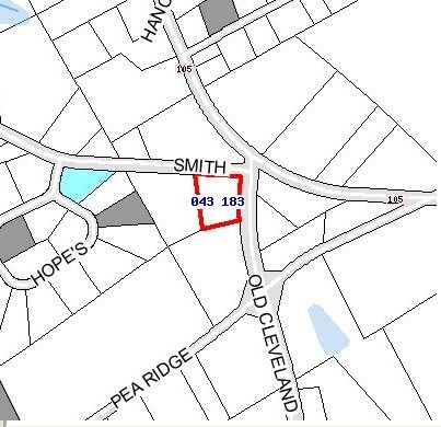
183 Smith Loop
043-183
10-69 PB 27-106 963-626
Residentialacreage
HABERSHAM
MI
Georgia
B and X Area of moderate flood hazard, usually the area between the limits of the 100-year and 500-year floods.
1.50 AC
2025
Georgia Northeast
2025
Other Market Areas
000603
Cornelia, GA
NEARBY LISTINGS FOR SALE OR LEASE
DEMOGRAPHICS near 183 Smith Loop
1 mile
3 mile
5 mile
2025 Total Population
914
7,859
29,374
2030 Population
971
8,445
31,716
Pop Growth 2025-2030
+ 6.24%
+ 7.46%
+ 7.97%
Average Age
42
40
40
2025 Total Households
345
2,868
10,589
HH Growth 2025-2030
+ 6.38%
+ 7.60%
+ 7.99%
Median Household Inc
$59,110
$61,063
$60,760
Avg Household Size
2.50
2.50
2.60
2025 Avg HH Vehicles
2.00
2.00
2.00
Median Home Value
$268,309
$247,446
$243,201
Median Year Built
1987
1990
1990
Nearby Places
Map Layers
Map Styles
 Street
 Aerial
Layers
 Traffic
 Biking
Places
Listings with unknown addresses are not visible on the map
- Restaurants
- Banks
- Shops
- Fitness
- Groceries
Nearby Properties
Address
Land Use
TOTAL SIZE
Lot Size
Zoning
Address
Land Use
TOTAL SIZE
Lot Size
Zoning
216,507 SF
159.83 AC
MI
Address
Land Use
TOTAL SIZE
Lot Size
Zoning
253,404 SF
22 AC
HI
Address
Land Use
TOTAL SIZE
Lot Size
Zoning
97,985 SF
30 AC
LI
Address
Land Use
TOTAL SIZE
Lot Size
Zoning
88,728 SF
37.73 AC
LI
Address
Land Use
TOTAL SIZE
Lot Size
Zoning
153,996 SF
24.72 AC
HI
Address
Land Use
TOTAL SIZE
Lot Size
Zoning
75,612 SF
29.13 AC
LI
Address
Land Use
TOTAL SIZE
Lot Size
Zoning
266,882 SF
152.11 AC
I
Address
Land Use
TOTAL SIZE
Lot Size
Zoning
57,800 SF
2.58 AC
SFR
Address
Land Use
TOTAL SIZE
Lot Size
Zoning
77,729 SF
69.23 AC
I
Address
Land Use
TOTAL SIZE
Lot Size
Zoning
55,608 SF
27.85 AC
I
Address
Land Use
TOTAL SIZE
Lot Size
Zoning
137,005 SF
20.74 AC
HI
Address
Land Use
TOTAL SIZE
Lot Size
Zoning
131,703 SF
15.25 AC
B1
Address
Land Use
TOTAL SIZE
Lot Size
Zoning
210,142 SF
27.50 AC
HI
Address
Land Use
TOTAL SIZE
Lot Size
Zoning
175,337 SF
10.63 AC
I
Address
Land Use
TOTAL SIZE
Lot Size
Zoning
27,492 SF
25.58 AC
LI
Address
Land Use
TOTAL SIZE
Lot Size
Zoning
21,168 SF
5.32 AC
HI
Address
Land Use
TOTAL SIZE
Lot Size
Zoning
76,344 SF
38.40 AC
HI
Address
Land Use
TOTAL SIZE
Lot Size
Zoning
47,520 SF
2.02 AC
HI
Address
Land Use
TOTAL SIZE
Lot Size
Zoning
35,720 SF
7.75 AC
HI
Address
Land Use
TOTAL SIZE
Lot Size
Zoning
87,830 SF
9.48 AC
B1
Address
Land Use
TOTAL SIZE
Lot Size
Zoning
32,210 SF
25.25 AC
HI
Address
Land Use
TOTAL SIZE
Lot Size
Zoning
66,994 SF
8 AC
I
Address
Land Use
TOTAL SIZE
Lot Size
Zoning
53.11 AC
HI
Address
Land Use
TOTAL SIZE
Lot Size
Zoning
42,053 SF
6.34 AC
B2
Address
Land Use
TOTAL SIZE
Lot Size
Zoning
21,880 SF
3.30 AC
HB
Address
Land Use
TOTAL SIZE
Lot Size
Zoning
29,040 SF
1.50 AC
B2
Address
Land Use
TOTAL SIZE
Lot Size
Zoning
57,730 SF
7.87 AC
HI
Address
Land Use
TOTAL SIZE
Lot Size
Zoning
305.22 AC
LI
Address
Land Use
TOTAL SIZE
Lot Size
Zoning
31,016 SF
1.45 AC
B1
Address
Land Use
TOTAL SIZE
Lot Size
Zoning
18,240 SF
8.19 AC
HI
The World's #1 Commercial Real Estate Marketplace
Connect with us
© 2026 CoStar Group
The information above has been obtained from sources believed reliable. While we do not doubt its accuracy we have not verified it and make no guarantee, warranty or representation about it. It is your responsibility to independently confirm its accuracy and completeness. Any projections, opinions, assumptions, or estimates used are for example only and do not represent the current or future performance of the property. The value of this transaction to you depends on tax and other factors which should be evaluated by your tax, financial, and legal advisors. You and your advisors should conduct a careful, independent investigation of the property to determine to your satisfaction the suitability of the property for your needs.